


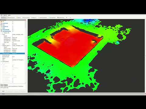
NavMap is an open-source C++ and ROS 2 library for representing navigable surfaces for mobile robot navigation and localization. Unlike classic grid-based maps, NavMap stores the environment as triangular meshes (NavCels), enabling efficient queries and multi-surface environments (e.g., multi-floor buildings).

 Funded by the European Union through the Horizon Europe programme under Grant Agreement No. 101070254 (CoreSense), and by MICIU/AEI/10.13039/501100011033 and ERDF/EU under grants PERMAP PID2024-161761OB-C21 and PLANNAV PID2024-161761OB-C22 (AURORAS).
- Triangular cell mesh representation with adjacency relations.
- Dynamic runtime layers: per-cell or per-vertex attributes (occupancy, elevation, cost, traversability, etc.).
- Locate API: find the NavCel under/around a 3D position using BVH acceleration and raycasting.
- Raytracing: Möller–Trumbore intersection with a simple BVH for efficiency.
- Multi-surface support: naturally supports multiple disconnected surfaces (e.g., separate floors).
- Unknown values and probabilistic occupancy: each layer can declare the value that means "not observed";
Occupancy.hppkeeps log-odds occupancy (OctoMap's clamped update) in an int16 layer, with free / occupied / unknown states. - Iterators over NavCels (
navmap_core/Iterators.hpp): box, disc, ring, polygon, distance order and segment walk; regions grow over the surface, so they never jump to another floor.
This repository is organized into several ROS 2 packages:
-
navmap_core/
Core C++ library implementing NavMap. Minimal dependencies (Eigen3). -
navmap_ros/
ROS 2 conversions and message definitions:navmap::NavMap↔navmap_ros_interfaces::msg::NavMapnav_msgs::msg::OccupancyGrid↔navmap::NavMap
-
navmap_rviz_plugin/
RViz2 plugin for visualization of NavMap messages:- Displays surfaces and layers.
- Optional per-cell normal rendering.
- Layer-based coloring.
-
navmap_tools/
Tools and utilities for building and testing NavMaps (mesh import/export, conversions, etc.) -
navmap_examples/
Practical examples demonstrating the usage of NavMap, both core C++ API and ROS 2 integrations.
NavMap can be built as a standalone C++ library or within a ROS 2 workspace.
# Clone into your ROS 2 workspace
cd ~/ros2_ws/src
git clone https://github.com/<your-org>/NavMap.git

# Build
cd ~/ros2_ws
colcon build --packages-up-to navmap_core navmap_ros navmap_rviz_plugin navmap_tools navmap_examples

# Source workspace
source install/setup.bash- C++23 compiler
- Eigen3
- ROS 2 (tested with Humble, Iron, Jazzy)
- RViz2 (for the visualization plugin)
- PCL (for mesh construction utilities)
This section shows small, self-contained snippets that demonstrate how to create a NavMap, add geometry, attach layers, query values, and locate the triangle (NavCel) corresponding to a 3D position.
Note: After modifying geometry (vertices, triangles, or surfaces), always call
rebuild_geometry_accels()before performing queries such aslocate_navcel()orraycast().
#include <navmap_core/NavMap.hpp>
#include <Eigen/Core>

using navmap::NavMap;
using navmap::NavCelId;

NavMap nm;

// Create a surface
std::size_t surf_idx = nm.create_surface("map");

// Add 4 vertices of a unit square (z=0)
uint32_t v0 = nm.add_vertex({0.f, 0.f, 0.f});
uint32_t v1 = nm.add_vertex({1.f, 0.f, 0.f});
uint32_t v2 = nm.add_vertex({1.f, 1.f, 0.f});
uint32_t v3 = nm.add_vertex({0.f, 1.f, 0.f});

// Add 2 triangles
NavCelId c0 = nm.add_navcel(v0, v1, v2);
NavCelId c1 = nm.add_navcel(v0, v2, v3);

// Assign them to the surface
nm.add_navcel_to_surface(surf_idx, c0);
nm.add_navcel_to_surface(surf_idx, c1);

// Build normals, adjacency, BVH, etc.
nm.rebuild_geometry_accels();// Add a layer of type float called "cost"
auto cost = nm.add_layer<float>("cost", "Traversal cost", "" , 0.0f);
// Assign values to each triangle
nm.layer_set<float>("cost", c0, 1.0f);
nm.layer_set<float>("cost", c1, 5.0f);double v = nm.layer_get<double>("cost", c0); // → 1.0size_t surf_idx;
NavCelId cid;
Eigen::Vector3f bary, hit;
bool ok = nm.locate_navcel(Eigen::Vector3f(0.5f, 0.5f, 0.1f),
surf_idx, cid, bary, &hit);
if (ok) {
std::cout << "Point belongs to surface " << surf_idx
<< ", NavCel " << cid
<< " with barycentric coords " << bary.transpose() << std::endl;
}double val = nm.sample_layer_at("cost", Eigen::Vector3f(0.2f, 0.8f, 1.0f), -1.0);
if (!std::isnan(val)) {
std::cout << "Cost at (0.2,0.8) is " << val << std::endl;
}If the layer does not exist or the position cannot be located, the fallback value (-1.0 here) is returned.
NavCelId hit_cid;
float t;
Eigen::Vector3f hit_pt;

bool hit = nm.raycast(
  Eigen::Vector3f(0.5f, 0.5f, 2.0f),   // origin
  Eigen::Vector3f(0.0f, 0.0f, -1.0f),  // direction
  hit_cid, t, hit_pt);

if (hit) {
  std::cout << "Ray hit NavCel " << hit_cid
            << " at " << hit_pt.transpose() << std::endl;
}You can set values over regions of the map using shapes such as circular or rectangular areas:
// Add an occupancy layer
nm.add_layer<uint8_t>("occupancy", "Occupancy", "%", 0);

// Mark a circular area at (0.5,0.5) with radius 0.3
nm.set_area<uint8_t>(Eigen::Vector3f(0.5f, 0.5f, 0.0f),
                     (uint8_t)254,
                     "occupancy",
                     navmap::AreaShape::CIRCULAR,
                     0.3f);

// Mark a rectangular area centered at (0.8,0.2)
nm.set_area<uint8_t>(Eigen::Vector3f(0.8f, 0.2f, 0.0f),
                     (uint8_t)200,
                     "occupancy",
                     navmap::AreaShape::RECTANGULAR,
0.35f);Visitors are called once per NavCel; returning false stops. Regions around a point grow from the NavCel under it through the mesh adjacency, so a disc on one floor never reaches the floor above. Reuse a TraversalScratch to avoid allocations.
#include <navmap_core/Iterators.hpp>

navmap::TraversalScratch scratch;
const Eigen::Vector3f robot(2.0f, 1.0f, 0.0f);

// NavCels within 0.5 m of the robot (3D distance to the centroid)
navmap::for_each_in_disc(nm, robot, 0.5f, [&](navmap::NavCelId c) {/* ... */},
  navmap::Metric::EUCLIDEAN, &scratch);

// NavCels crossed by a sensor ray projected on the surface, with the entry/exit parameters
navmap::for_each_on_segment(nm, robot, Eigen::Vector3f(6.0f, 3.0f, 0.0f),
  [&](navmap::NavCelId c, float t_in, float t_out) {/* clear c */});

// Nearest NavCel along the surface (geodesic order) with a free value
navmap::for_each_by_distance(nm, seed, robot, 3.0f, [&](navmap::NavCelId c, float d) {
    return nm.layer_get<uint8_t>("occupancy", c) != 0;  // false stops at the first free one
  });
Also for_each_in_aabb (every surface, via the BVH), for_each_in_ring and for_each_in_polygon (XY polygon on the seed's floor). Metric::GEODESIC measures along the surface and bends around borders; it is about 80 times costlier than EUCLIDEAN, so use it for occasional queries.
#include <navmap_core/Occupancy.hpp>

nm.add_layer<float>("elevation", "terrain height", "m", 0.0f);
nm.set_layer_unknown("elevation", std::numeric_limits<double>::quiet_NaN());  // NaN = not surveyed
bool unseen = nm.is_unknown("elevation", cid);

navmap::OccupancyLayer occ(nm);   // int16 layer "occupancy_logodds", all unknown
occ.miss(crossed_cid);            // a ray crossed it
occ.hit(end_cid);                 // a ray ended on it
if (occ.state(cid) == navmap::OccupancyState::OCCUPIED) {/* ... */}
The unknown value, description and unit of each layer travel in the message and in the file. Which NavCels a ray hits or crosses is up to the algorithm using it (see for_each_on_segment). ros2 launch navmap_examples unknown_occupancy.launch.py shows both in RViz2 (build with -DBUILD_ROS_EXAMPLES=ON).
Layers record which NavCels changed since the last clear_changes() (layer_set, OccupancyLayer; bulk writes mark the whole layer), so a consumer only reprocesses what changed. DistanceField keeps a distance-to-seed field up to date from the seed cells added and removed:
#include <navmap_core/DistanceField.hpp>

navmap::DistanceField df(nm, /*from_boundary=*/true, /*max_distance=*/0.7f);
df.compute(lethal_cells);                       // once
df.update(newly_lethal, no_longer_lethal);      // every cycle: cost of the area that changes
for (navmap::NavCelId c : df.changed()) {/* recompute the cost of c from df[c] */}
With a finite max_distance the field is exact (straight distance to the nearest seed reaching the NavCel over the surface), and identical after any sequence of updates to a full recomputation.
navmap::compute_descriptors(nm) adds F32 layers per NavCel: slope (deg), roughness (RMS distance to the plane fitted in a disc, m), step (height span in a small disc, m) and clearance (free height to the next surface of the map above, m; +inf if none). Discs grow over the surface, so floors never mix. They only describe the surface: weighing them into a cost is up to the planner.
Stairs, elevators or doors between NavCels that do not share an edge. The map only records them; whether a robot can take one, and at which cost, is up to the planner. They travel in the message and the file, and RViz2 draws them (Draw Links).
nm.add_link(ground_cid, upper_cid, navmap::LinkType::ELEVATOR);            // both ways
nm.add_link(top_cid, bottom_cid, navmap::LinkType::STAIRS, 4.5f, false);   // one way, 4.5 m
for (std::uint32_t i : nm.links_from(cid)) {const auto & l = nm.links()[i]; /* ... */}Each source keeps its own layer (a static prior, obstacles from a sensor, a keep-out zone), and a master layer is composed from them with navmap::combine_layer(nm, dst, src, op, options). The operators are those of costmap_2d: OVERWRITE, TRUE_OVERWRITE, MAX, MAX_KEEP_UNKNOWN, MIN and ADD (saturating at options.cap). Each layer's declared unknown value is respected, types may differ, options.cells restricts the work to the cells that changed, and options.provenance names a U8 layer that records which source set each cell. Clearing the sensor layer never erases the prior, because the sensor never writes it. The cost values (navmap_core/Costs.hpp) are those of costmap_2d.
#include <navmap_core/Combine.hpp>

navmap::CombineOptions o;
o.provenance = "source";
o.source_id = 1;
navmap::combine_layer(nm, "cost", "prior", navmap::CombineOp::TRUE_OVERWRITE, o);
o.source_id = 2;
o.cells = nm.layers.get("obstacles")->changed();
navmap::combine_layer(nm, "cost", "obstacles", navmap::CombineOp::MAX, o);navmap::simplify(nm, params) merges NavCels where the surface is flat (within max_error) and the layers have the same value, and keeps the original ones where they change: every layer keeps its value at every point, open edges keep their shape and the topology does not change (floors, holes, links). max_edge_length bounds the NavCel size. Layers that are per-cell geometry (elevation, support from from_points) go in ignore_layers.
ros2 run navmap_tools navmap_simplify in.navmap out.navmap --max-error 0.02 \
--ignore-layer elevation --ignore-layer support| Map (playgrounds) | NavCels | max_error |
After | File (zlib) |
|---|---|---|---|---|
home2_20cm (occupancy grid) |
10 716 | 0.02 m | 22.6 % | 248 KB → 16 KB |
warehouse_20cm (occupancy grid) |
18 720 | 0.02 m | 21.4 % | 433 KB → 25 KB |
parking_garage (from_points) |
38 543 | 0.02 / 0.1 m | 10.6 / 4.2 % | 1.06 MB → 56 / 24 KB |
excavation_urjc (from_points) |
29 728 | 0.02 / 0.1 m | 67 / 38 % | 822 KB → 235 / 142 KB |
Conversion functions are provided in navmap_ros:
#include <navmap_ros/conversions.hpp>
#include <navmap_ros_interfaces/msg/nav_map.hpp>

// Convert to ROS message
navmap_ros_interfaces::msg::NavMap msg = navmap_ros::to_msg(nm);

// Convert back to core structure
navmap::NavMap nm2 = navmap_ros::from_msg(msg);navmap_ros::to_layer_update_msg(nm, "obstacles") publishes only what changed since the layer's last clear_changes(): a sparse NavMapLayer (indices + values) when few NavCels changed, the full layer otherwise. Every NavMap and NavMapLayer message carries the map's geometry_id, so from_msg (and RViz2) reject updates meant for another geometry.
#include <navmap_ros/navmap_io.hpp>

navmap_ros::io::save_to_file(nm, "/tmp/map.navmap");     // zlib-compressed by default
navmap::NavMap nm3;
navmap_ros::io::load_from_file("/tmp/map.navmap", nm3);
File format.
.navmapfiles are version 2: the CDR-serializedNavMapmessage (layer metadata, int16 layers, links, geometry id), zlib-compressed by default (SaveOptions::compression,level). zlib is available on every ROS distro and in the Python standard library. Version 1 files, and files without header, still load: they are migrated with a deprecation warning and rewritten in place when the location is writable.
For advanced control you can still access internal data directly:
// Access vertex positions
Eigen::Vector3f v = nm.positions.at(0);

// Iterate over NavCels
for (const auto & cel : nm.navcels) {
  Eigen::Vector3f centroid = nm.navcel_centroid(&cel - &nm.navcels[0]);
  std::cout << "NavCel area: " << cel.area
            << " centroid: " << centroid.transpose() << std::endl;
}In addition to the snippets above, the repository provides the package navmap_examples with ready-to-run executables.
colcon build --packages-select navmap_examplesIf your navmap_core / navmap_ros do not yet export CMake targets, you can provide include paths:
colcon build --packages-select navmap_examples --cmake-args -DNAVMAP_CORE_INCLUDE_DIR=~/ros2_ws/src/NavMap/navmap_core/include -DNAVMAP_ROS_INCLUDE_DIR=~/ros2_ws/src/NavMap/navmap_ros/includeDisable ROS 2 examples:
colcon build --packages-select navmap_examples --cmake-args -DBUILD_ROS_EXAMPLES=OFFros2 run navmap_examples 01_flat_plane
ros2 run navmap_examples 02_two_floors
ros2 run navmap_examples 03_slope_surface
ros2 run navmap_examples 04_layers
ros2 run navmap_examples 05_neighbors_and_centroids
ros2 run navmap_examples 06_area_marking
ros2 run navmap_examples 07_raycast
ros2 run navmap_examples 08_copy_and_assignEach demonstrates a different feature: geometry creation, multi-surface, U8/F32 layers, centroids and neighbors, area marking, raycasting, and copy/assign semantics.
If BUILD_ROS_EXAMPLES=ON:
ros2 run navmap_examples 01_from_occgrid
ros2 run navmap_examples 02_to_occgrid
ros2 run navmap_examples 03_save_load
Or via launch:
ros2 launch navmap_examples navmap_to_occgrid.launch.pyNavMap provides unit tests with GTest. To run them:
colcon test --packages-select navmap_core navmap_ros
colcon test-result --verboseContributions are welcome! Please open issues and pull requests on GitHub.
Before submitting code, run the linters and tests:
colcon test
ament_lint_autoThis project is licensed under the Apache 2 License.
See the LICENSE file for details.
Developed at the Intelligent Robotics Lab (Universidad Rey Juan Carlos).
Part of the Easy Navigation (EasyNav) project.